


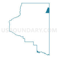
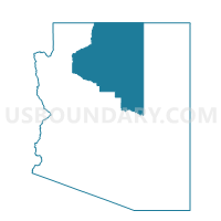
Inscription House Voting District, Coconino County, Arizona
About
Outline

Summary
| Unique Area Identifier | 523722 |
| Name | Inscription House Voting District |
| County | Coconino County |
| State | Arizona |
| Area (square miles) | 159.38 |
| Land Area (square miles) | 159.32 |
| Water Area (square miles) | 0.06 |
| % of Land Area | 99.96 |
| % of Water Area | 0.04 |
| Latitude of the Internal Point | 36.64796460 |
| Longtitude of the Internal Point | -110.80698590 |
Maps

Graphs
Select a template below for downloading or customizing gragh for Inscription House Voting District, Coconino County, Arizona


Neighbors
Neighoring Voting District (by Name) Neighboring Voting District on the Map
- Kaibeto Voting District, Coconino County, AZ
- Navajo Mountain Voting District, Coconino County, AZ
- Shonto Voting District, Navajo County, AZ
- Tonalea North Voting District, Coconino County, AZ
Top 10 Neighboring County Subdivision (by Population) Neighboring County Subdivision on the Map
Top 10 Neighboring Unified School District (by Population) Neighboring Unified School District on the Map
- Tuba City Unified District, AZ (16,064)
- Page Unified District, AZ (13,046)
- Kayenta Unified District, AZ (10,479)